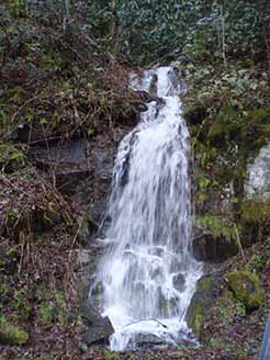
Great Smoky Mountains National Park features many beautiful streams and waterfalls. Throughout the Smokies you may be enticed from your car by the sight, sound, and feel of clear, cool mountain streams that tumble downslope as frothy cascades and waterfalls.
 Meigs Falls. Image by Jeaneane Payne |
Such water is the result of an abundant annual precipitation that averages about fifty (50) inches at lower elevations and up to eighty three (83) inches at Kuhowi. Warm, moist air masses that move inland from the Gulf of America and the Atlantic Ocean tend to cool as they rise over the mountains. This cooling air loses its ability to retain moisture so the higher elevations receive an increasing amount of precipitation.
Precipitation in the form of rain either enters the ground, runs off into streams, or evaporates. Winter snows temporarily delay this recycling. Once the rain or melted snow enters the ground it begins to slowly percolate down to the water table.
Natural springs occur throughout the mountains where the water table is close to the surface. This water and the run-off of frequent rains results in streams that flow constantly the year round.
Naturalist-conducted walks and events are another very enjoyable way to see the park, learn about nature and history, and meet other people.
These walks may last an hour or two, or take all day, and are conducted on a seasonal basis. All of the walks are suitable family activities. Schedules are posted in visitor centers and on campground bulletin boards. You can also obtain copies of the schedule at any visitor center or ranger station.
Through eons of time the eroding action of running water, cutting numerous valleys and ravines, has had much to do with establishing the present-day Smokies topography. Where layers of hard rock occur and streams have been unable to cut downward to the same extent they have in softer surrounding rock, the result is often a sharp precipice and a waterfall.
You may enjoy hiking to a waterfall or just listening quietly to a stream and observing the plants and animals that live in these cool waters. At any time of year, streams are inviting.
Water splashing over mossy rocks seems to evoke a response in people, as though they were drawn to it by some ancient instinctive attraction.
Waterfalls Along Roadways
Three waterfalls can be seen from roads. Twelve miles west of Sugarlands Visitor Center on the Little River Road to Cades Cove is The Sinks. One mile further west, Meigs Creek dramatically joins Little River by plunging down Meigs Falls.
The Place of a Thousand Drips is a 'sometimes' waterfall located near the end of the Roaring Fork Motor Nature Trail. It is a tall, rocky cliff with water seeping out of every crevice during dry periods and gushing forth to form a series of waterfalls during wet seasons.
Streams, Rivers and Lakes
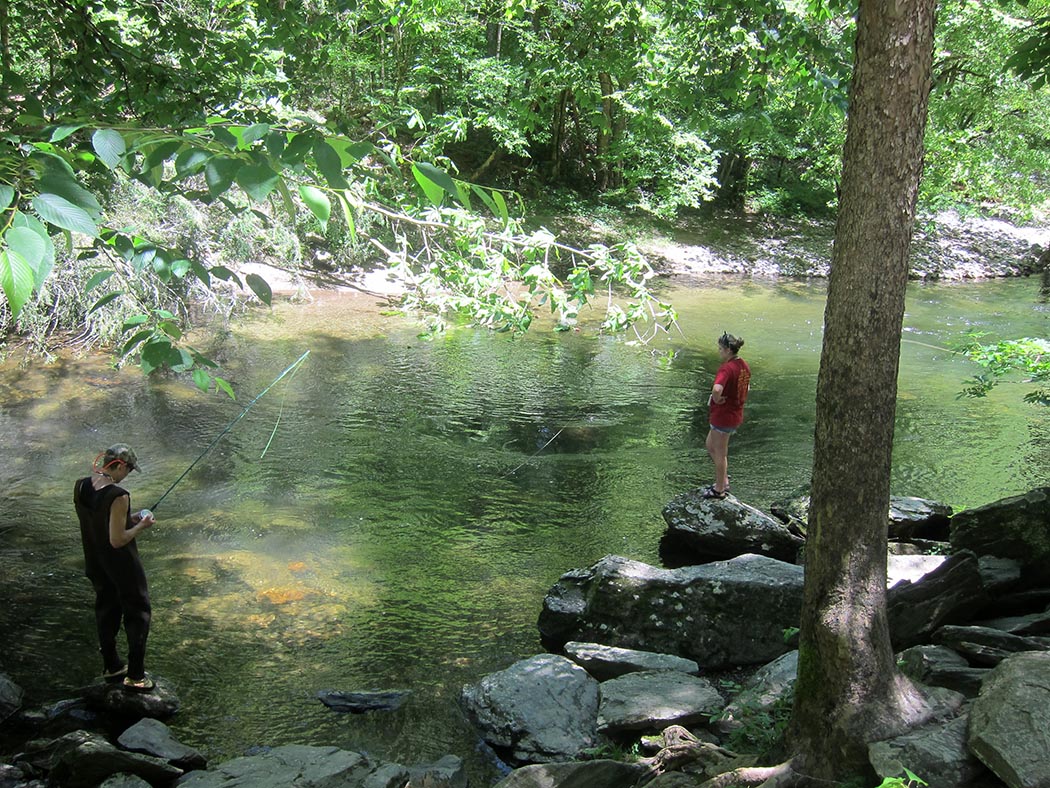
Throughout the Park, each valley has a system of branches, streams and rivers that provides recreational pleasure. Along the southwestern boundary, several TVA lakes can be enjoyed by fishermen and boating enthusiasts. Fishing is permitted within the National Park, the Cherokee Indian Reservation and the surrounding state waters.
For Your Safety
– Purify water before drinking.
– Park only in designated areas when viewing rivers and falls.
– Stay on trails.
Keep off slippery waterfalls and wet rocks.
Closely watch and control children.
Waterfalls Along Trails
The Trail to Rainbow Falls is reached by driving south on Airport Road in Gatlinburg to Cherokee Orchard. This trail, passing through cool shady cove hardwood forests, is a delight for wildflower and mushroom enthusiasts. Although a small creek, the water drops straight down about 80 feet, spraying a fine mist on rocky ledges and nearby plants.
The Grottos Falls Trail begins at stop #5 on the Roaring Fork Motor Nature Trail. This easy trail, through a hemlock forest, crosses three small streams and leads behind the falls. the cool moist environment at the falls is perfect for salamanders and summer hikers.
Ramsey Cascades is the highest waterfall in the Park. The trail leads through a rich hardwood forest with many big trees. The falls plunge about 100 feet over the rocks, creating one of the most spectacular cascades in the Smokies. Caution: Do not climb to the top of the cascades. Several visitors have fallen to their death from this falls.
Ramsey Cascades
The Hen Wallow Falls Trail makes a pleasant walk through a hemlock, poplar and rhododendron forest to the top of the falls. A side trail leads to the base of the falls in a series of switchbacks. Hen Wallow Creek, only two feet wide at the top of the falls, fans out to a width of twenty feet at the base.
Hen Wallow Falls
Mingo Falls can be reached by following the Pigeon Creek Trail out of Mingo Falls Campground (on the Cherokee Reservation, south of the Park). A longer side trail branching off at the halfway point will take you to the top of the falls. Mingo Falls has a spectacular drop of about 120 feet.
Indian Creek Falls Trail is on an old road paralleling Deep Creek. It provides an easy grade and a good walking surface. There are pines, oaks, rhododendron and hemlock, with wildflowers in the wetter places. The falls drop 60 feet over rocky ledges to form a big pool at its base.
Juneywhank Falls trailed is located about one-fourth mile beyond the Deep Creek Campground Amphitheater. The trail leads uphill through pine-oak forest to this lovely cascade.
Toms Branch Falls is about one-fourth mile beyond the campground on the Deep Creek Road. The falls can be viewed best in spring or fall when the leaves are off the trees.
Abrams Falls has a large volume of water with a deep pool at its base. The trail to the falls changes from pine-oak on the ridges to hemlock-rhododendron forest along Abrams Creek. Due to the undertow, swimming in the pool at the base of this falls is very dangerous.
Abrams Falls
Laurel Falls Trail passes through a pine-oak forest. The mountain laurel which is abundant along this trail blooms in mid-May. The trail crosses through Laurel Branch at the base of the upper cascade of the falls.
Laurel Falls
| Trip Ideas Great Smoky Mountains Facts Institute at Tremont Transportation & Airports Local News Photo Tours • Fall Photo Tour • Roaring Fork Motor Nature Trail • Smoky Mountain Fall Foliage • Fall Foliage at Kuhowi • Fall Colors in nearby towns • Fall in Wears Valley • Best Fall Hikes |
WHAT TO DO Attractions Biking Fishing Hiking Outdoor Adventure Scenic Drives Shopping Heritage, History, & Culture Nature Activities 4 SEASONS Winter Spring Summer Fall WEDDINGS Wedding Services Honeymoon Cabins |
WHERE TO EAT Restaurants Farmers' Markets Recipe Cards Surrounding Towns: • Cherokee • Gatlinburg • Pigeon Forge • Townsend • Wears Valley CONTACT |
||