
Cades Cove History
Europeans first settled Cades Cove in 1818.
Most settlers migrated from the Watauga Settlement in northeast Tennessee. Before their arrival, Cades Cove was part of the Cherokee Nation. The Cherokee called the cove Tsiyahi, "place of the river otter." In addition to river otters, elk and bison lived in the Cove. Hunters extirpated them before settlement. The Cherokee never lived in the Cove, but they used it as a summer hunting ground. Arrowheads are common throughout the Cove.
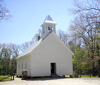 After Charles pointed out the house, the soldiers dragged Russell out, and killed him on the spot. Russell became a martyr, giving his life for the Cove's people. His tombstone epithet reads "Russell Gregory, murdered by North Carolina rebels." Charles eventually received forgiveness. His grave lies behind his father's in the Primitive Baptist Church Cemetery (pictured above). |
|
Before the American Revolution, the Cherokee discouraged settlers. After the defeat of their English allies, they sought peace. Most Cherokees accepted this peace and the new United States government. They tried to integrate European technologies and culture with their own. The Cherokee adapted well. They built modern houses, attended school, and by 1820 they created a written language. The 1830 U.S. census showed more than 1,000 slaves working on Cherokee plantations.
Despite the Cherokee's assimilation, many Americans wanted to move all Indians west of the Mississippi River. The discovery of gold on Cherokee lands, and Andrew Jackson's rise to the Presidency, led to their removal and the tragic "Trail of Tears." More than 14,000 Cherokees left the Southern Appalachians in 1838. Winter cold, disease, despair, and the United States Army escorted the Cherokees west. Less than 10,000 reached Oklahoma. A few Cherokees refused to move. They hid among the Smoky Mountain wilderness, avoiding the army and local authorities. In 1870s, the U.S. government allowed these renegade Cherokees, now called the Eastern Band, to claim some of their lands in western North Carolina. This is the Qualla boundary.
Cherokee removal opened Cades Cove and surrounding areas for settlement without fear of Indian harassment. In 1850 the Cove's population reached 685. Settlers farmed the fertile limestone-based soils and searched for valuable minerals. While crops grew abundantly, the mineral wealth never materialized.
The Civil War shattered Cades Cove. No slave ever worked the Cove, and the mountain people shared few cultural ties with the South. Still young men fought for both sides, 21 for the Union and 12 for the Confederates. Most remaining residents were pro-Union, but surrounded by hostile territory, they paid for their northern sympathies. From 1862-1864, a Confederate regiment, Thomas' Legion, terrorized the Cove by stealing livestock, harassing children, and taking prisoners. Small children guarded the mountain tops, blowing horns when the Confederates approached.
The story of Russell Gregory (founder of Gregory's Bald) and his son Charles best portrays East Tennessee's bitter Civil War divisions. Russell had strong Union sentiments, but was too old to fight. His son Charles supported the Confederates and joined Thomas' Legion in 1862. Russell, upset at the continuing raids, organized an ambush. The Cove's remaining men surprised the Confederates, forcing a retreat. One of the Confederates was Charles Gregory. He recognized his father's gun when it fired the first shot. Charles retreated with his comrades, informing them that his father led the ambush. The Confederates returned later that night, and Charles pointed out his father's home. Charles did not realize the revenge his fellows had in mind.
After Charles pointed out the house, the soldiers dragged Russell out, and killed him on the spot. Russell became a martyr, giving his life for the Cove's people. His tombstone epithet reads "Russell Gregory, murdered by North Carolina rebels." Charles eventually received forgiveness. His grave lies behind his father's in the Primitive Baptist Church Cemetery.
The Civil War changed the Cove's culture. Ravaged by the Confederates, and abandoned by the Union, the people of Cades Cove no longer trusted or welcomed outsiders. The Cove turned inward, developing a fierce independence. Immigration stopped. Without new blood, the residents intermarried. By 1900, most of the Cove's 700 residents were relations.
Around 1900, logging concerns discovered the Smoky Mountains. During the next 30 years, they clearcut 67% of the future Park. Logging brought employment and hard currency to the mountaineers, but destroyed the environment. In the early 1920s the Park movement began. In Cades Cove, more than half the residents accepted the cash offered for their land. The others fought the Park movement. John W. Oliver, great-grandson of Cades Cove's first settler, led the effort. His spirited fight against Tennessee's state government ended in the State's Supreme Court. A compromise allowed the Cove people to remain in their homes with a life-time lease.
| Trip Ideas Great Smoky Mountains Facts Institute at Tremont Transportation & Airports Local News Photo Tours • Fall Photo Tour • Roaring Fork Motor Nature Trail • Smoky Mountain Fall Foliage • Fall Foliage at Kuhowi • Fall Colors in nearby towns • Fall in Wears Valley • Best Fall Hikes |
WHAT TO DO Attractions Biking Fishing Hiking Outdoor Adventure Scenic Drives Shopping Heritage, History, & Culture Nature Activities 4 SEASONS Winter Spring Summer Fall WEDDINGS Wedding Services Honeymoon Cabins |
WHERE TO EAT Restaurants Farmers' Markets Recipe Cards Surrounding Towns: • Cherokee • Gatlinburg • Pigeon Forge • Townsend • Wears Valley CONTACT |
||