Roaring Fork Motor Nature Trail connects with Cherokee Orchard Road to form an 11-mile loop. The one-way road runs for 8 miles. The drive itself takes about an hour and a half if you stop to capture pictures. To visit the historic buildings, add on another hour. If you want to hike one of the trails, allow additional time based on the trail length.
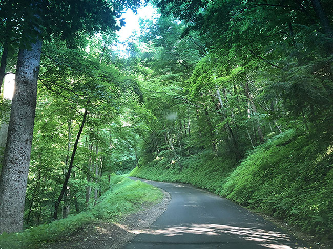 |
The motor trail is not suitable for bicycles, RVs, trailers, or buses. Cherokee Orchard Road is a two way road without these restrictions and leads to the Rainbow Falls parking area. Historic Nature Trail in Gatlinburg turns into the Park's Cherokee Orchard Road.
Take the Photo Tour
Driving Directions:
In downtown Gatlinburg turn onto Historic Nature Trail. Travel 2.2 miles to the entrance of Cherokee Orchard Road. This driving trail is a one-way road which runs for 8 miles.
 |
 |
 |
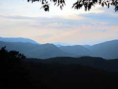
Overlook |
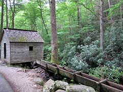
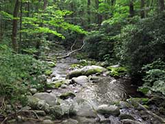
Elys Mill | River runs through the trail |
* Romantic Weekend in Gatlinburg: The Couples' Guide to the Smokies *
The Roaring Fork Motor Nature Trail is an intimate journey through the Smoky Mountain's lush mountain wilderness. In places, it reveals some of nature's secrets, while in others it weaves the story of the people who once lived here. Water is a constant companion on this journey. Cascades, rapids, and falls adorn the roadside. The sound of rushing water is never far away. The air feels damp and tropical throughout the summer months, yet the icy water rarely reaches 60o F.

Along the route are many hiking trails including the hike to Grotto Falls. This same trail continues to Brushy Mountain and Mt. LeConte. At the end of Roaring Fork Motor Nature Trail, you will find Ely's Mill, a family owned and operated mill built in 1925.

Healthy second growth forests escort the road on its journey. A few better drained ridges support a pine-oak forest, but cove hardwoods and hemlocks dominate the landscape. Rhododendron's thick, sprawling foliage green the understory year-round. In early July their pink blooms highlight the shadowy forest.
The Roaring Fork Motor Nature Trail is open to vehicle traffic from early spring until December 1 each year.

Hiking Trails Accessible from
Roaring Fork
Motor Nature Trail:

Bullhead Trail is the trailhead to the Rainbow Falls Trail. Many hikers ascend one trail and descend the other. Because of its seclusion, the trail is the least popular route along Mount Le Conte. It is this isolation that makes the trail so desirable to those who favor solitude when hiking.
Grapeyard Ridge trail has many creek crossings on log bridges. As you head up Injun Creek you will find an old Indian burial ground then a side trail to visit the McCarter Cemetery, passing many rock piles and stone fences. Next camp #32 where Injun Creek and Grapeyard Ridge trail cross. Go up Grapeyard trail, toward Roaring Fork, looking for a tree with very twisted branches. That tree signaled the spot to start the manway portion of the hike. This manway, in the old days, was used to get from Grapeyard Ridge to Greenbrier. Women rode sidesaddle on this trail to town. The trail is now an overgrown manway, but the trail is still very visible with just a few blow downs. Follow the manway for about 3 miles before coming to a huge hollowed out chestnut stump. At that point take a right turn and go down a fairly steep hill. In about 3/4 mile you will be at the 2nd parking lot you passed to the trail head.
Old Sugarlands Trail was the original first paved road to Newfound Gap. Before the road was paved it was a wagon road through the center of the Sugarlands Community. A quarry near the trail was used to build the first paved roads over the mountains. The first 1.5 miles are narrow and flat. If you look carefully, the signs of the past inhabitance can been seen from the work of the CCC. At 2 miles the trail begins a gradual climb. After the nice climb you have reached the second portion of the trail. Turn left heading down the Cherokee Orchard Road, and you will see the trail head to the next trail "Twin Creeks trail" This trail follows the road for only a short distance then heads off into the thick trees. You will have a minor creek crossing. This trail takes you to the Ogle home. Follow the road into Gatlinburg, have some lunch, then head west on 441 and you will see the last leg, Gatlinburg Trail. this 2.5 miles follows the river, is peaceful and flat.
Rainbow Falls Trail is a fairly challenging trail if completed all the way to Mt LeConte. It takes about an hour and a half to hike to Rainbow Falls and four hours to Mt LeConte. Hikers will gain nearly 4,000 feet in elevation by the time they get to Mt. LeConte.
Directions: Turn at light #8 in Gatlinburg and follow Historic Nature Trail 1 mile into Great Smoky Mountains National Park. The name will change from Historic Nature Trail to Cherokee Orchard Road. About 2.5 miles after entering the Park, Cherokee Orchard Road approaches the Rainbow Falls parking area. You will find the trail head at one edge of the parking area.
Trillium Gap trail is the only horse trail to Mt LeConte and is traveled three times a week by llamas transporting supplies to the LeConte Lodge, except during the winter season, when the lodge is temporarily closed.
The Trillium Gap Trail begins its 6.5 mile journey up the northern face of Mt LeConte at an elevation of about 3,200 ft. Although an easy trail, this portion of the trail does have many small creek crossings, so the hiker may want to brush up on rock hopping skills before hiking this trail. After the third small stream, Grotto Falls is 1.3 miles. Here Roaring Fork tumbles thirty feet over the falls. Grotto Falls is one of the most picturesque waterfalls in the park. The trailhead is located inside Great Smoky Mountains National Park, about 7.5 miles from Gatlinburg, Tennessee, off Roaring Fork Motor Nature Trail.
Twin Creeks Trail is more rugged than most trails in the Smokies. The forest here is scraggly and seems to be struggling to recover from years of pre-park farming and clearing. Poison ivy covers the trail, and you’re within earshot (sometimes eyesight) of the road the entire way. This is an easy family walk.
| Trip Ideas Great Smoky Mountains Facts Institute at Tremont Transportation & Airports Local News Photo Tours • Fall Photo Tour • Roaring Fork Motor Nature Trail • Smoky Mountain Fall Foliage • Fall Foliage at Kuhowi • Fall Colors in nearby towns • Fall in Wears Valley • Best Fall Hikes |
WHAT TO DO Attractions Biking Fishing Hiking Outdoor Adventure Scenic Drives Shopping Heritage, History, & Culture Nature Activities 4 SEASONS Winter Spring Summer Fall WEDDINGS Wedding Services Honeymoon Cabins |
WHERE TO EAT Restaurants Farmers' Markets Recipe Cards Surrounding Towns: • Cherokee • Gatlinburg • Pigeon Forge • Townsend • Wears Valley CONTACT |
||