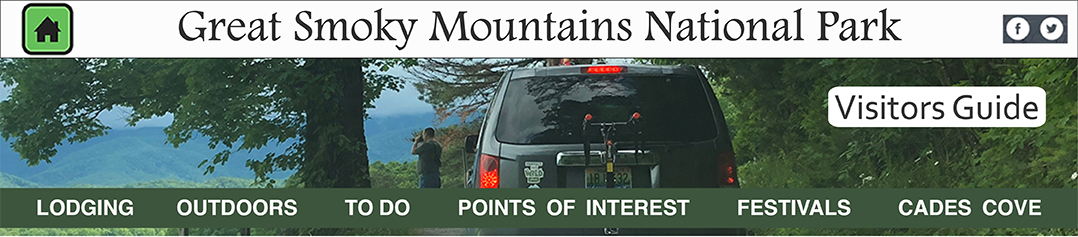
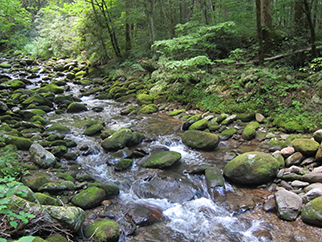
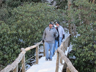
Great Smoky Mountains National Park provides many opportunities for walking and hiking. The National Park Service maintains 800 miles of trails inside the park. Much of the interest and mood present in the park depends on finding subtle variations in nature not seen from automobiles. For example, wildflowers, cascading streams, the scent of evergreens, and the sounds of birds are best seen and experienced away from roads.
 |
 |
|
|---|---|---|
 |
 |
|
 |
 |
|
 |
 |
Things to bring when hiking in the Smokies:
• Comfortable walking shoes
• High energy food
• Flashlight
• Whistle
• Knife
• First aid kit
• Extra clothing
• Matches
• Water
• Raingear
• Trail maps
• Compass
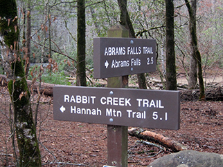
• Abrams Falls Trail (five miles round trip) is an easy, relatively flat trail leading to the 20-foot high Abrams Falls which spills into a scenic pool. The trail begins at the Abrams Falls parking lot at the west end of Cades Cove Loop Road. Elevation gain is 340 feet.
• Ace Gap hike is one of the most peaceful trails in Cades Cove. It is about five and a half miles in length, without much altitude gain or loss. In the month of May, parts of the Ace Gap trail are strewn with pink Lady's Slippers. All wildflowers in Cades Cove are protected by law and may be admired and photographed, not picked or dug.
The trailhead to Ace Gap trail is down Cades Cove loop and up Rich Mountain Road. Near the trailhead, Smokies hikers pass Bull Cave, the largest cave in Cades Cove. The bottom of the cave is fully five hundred feet from the surface almost straight down.
Smokies hikers on the Ace Gap trail will ascend from the Cades Cove floor past the mouth of the cave. Once beyond the cave, the trail meanders five miles along the ridges of Rich Mountain to the place known as Ace Gap. Ace Gap was so named for card playing loggers that once congregated there. You will know you have come to Ace Gap when you come to an old railroad bed. Logging trains once clacked along railroad tracks all over Cades Cove during the expansion of the United States. Cades Cove and many other parts of the country yielded up virgin forests while filling a seemingly endless demand for lumber for homes, buildings and bridges. The trains which once traveled along the Ace Gap track were owned by the Little River Lumber Company and carried equipment, loggers and logs through Cades Cove.
• The Albright Grove Trail winds up a small creek and through an ancient forest that gives one a hushed, and even sacred, feeling.
• Alum Cave Bluffs Trail (11 miles round trip) starts off easy but become difficult. An initial one-and-a-half-mile trail takes you through Arch Rock's erosion-created tunnel. the next 0.8 mile is steeper and leads to Alum Cave Bluffs which is a 100-foot high cliff. This last half of the trail is steep and, at times, hikers must grip trailside cables to traverse cliffs. The trail begins at the Alum Cave Bluffs parking area at Newfound Gap Road between Newfound Gap and Chimney Tops on the Tennessee side of the Smoky Mountains. Elevation gain is 2,800 feet. Photos
• Anthony Creek Trail starts at the beginning of the Cades Cove in the picnic area and goes three and a half miles up Bote Mountain for a 3000 altitude gain. Hikers should anticipate the need for water as this can be a strenuous hike. Despite the difficulty of the hike, Smokies visitors using the Anthony Creek trail enjoy beautiful scenery as well as wonderful views from Spence Field and Rocky Top, both locations being important in Cades Cove history. To get to Spence Field and Rocky Top you travel the Anthony Creek Trail to the Bote Mountain Trail and the Appalachian Trail. Photos
Anthony Creek Trail also features the headwaters of Anthony Creek. The popular Cades Cove trail also goes by the horse camp, a delight to horsemen as well as goes by backcountry camp sites. Due in part to the location of the trailhead, the Anthony Creek Trail is one of the most traveled in Cades Cove.
• The Appalachian Trail (2,100 miles) was proposed by conservationist Benton MacKaye in 1921. Work on the trail began the following year and by 1937, the trail was complete. The first person walked its entire length from Georgia to Maine in 1948. Every year, some 100 hikers repeat the feat. Successful hikers include a six-year-old boy, several octogenarians, and a visually impaired man with his guide dog (Blind Courage). The entire trip takes four to six months, crossing 14 states, eight national forests, two national parks and 15 major rivers. Elevations range from 6,643 feet at Clingsmans Dome in the Smokies to near sea level at the Hudson River in New York. the segment within the park follows the Smokies ridgeline 69 miles for nearly the entire length of the park. You can access the trail at Newfound Gap to Charlies Bunion, which passes through a spruce fir forest with spectacular vistas. The eight mile round trip walk has an elevation gain of 980 feet.
• Beard Cane Trail is named for a cane variety which grows locations in Cades Cove where the terrain is moist. The Beard Cane trail is one of a few relatively flat trails in Cades Cove and for that reason it is wonderfully suitable for an amble in the woods. An easy hike that takes the Smokies visitor down the hollow between Beard Cane and Hatcher mountains, the Beard Cane trail is known for being beautifully strewn with wildflowers and flowering shrubs such as polygala, trillium, rhododendron, and dog-hobble. Overhead trees such as oak, tulip, hemlock and maple trees canopy this Cades Cove hike. Try not to go after a rain however as the Beard Cane Trail, can be very muddy after rains.
• Boogerman Trail is named for Robert "Boogerman" Palmer, whose homesite you will see as you complete this moderately challenging 7-mile loop trail, which can take between 2 and 3 hours to complete. You will gain nearly 850 feet on your way to 3,600 feet at the trail's highest point. The trail is well maintained, and this hike offers views of some of the largest trees in the area, old homesites (including Palmer's) and mountain streams. This area was spared from the logging operations which dominated much of the Smokies area before the land was purchased for the Park.
At mile 3.8 of your loop, the trail turns down to the right alongside Snake Branch, around a rock wall, and across a small stream. Here you will see some clearings, old fence posts and piles of stone, which indicate where homesites previously existed near the creek.
Nearing the five-mile point you will cross Snake Branch. In an area of towering hemlocks you will begin crossing Caldwell Fork several times via log footbridges. The stream offers up picturesque views of both quiet, deep pools, and noisy falls. Several hundred yards before crossing Cataloochee Creek at approximately mile 7.4, and completion of the loop, you will see the remains of a cabin and barn built by Carson Messer.
After following the directions from I-40, NC 276, and Cove Creek Road, navigate your way to the Caldwell Fork Trail (follow the signs). Cross Cataloochee Creek on a footbridge and you'll enter a stand of white pines. When the trail splits, stay right and climb a narrow edge along Caldwell Fork. You'll cross Caldwell Fork on a footbridge and enter an area of old-growth trees. You will pass through a gap and traverse an area dominated by white pines. At mile 2.8, you will encounter the Palmer (Boogerman) homesite.
• Bote Mountain Trail. During the 1800's, James Spence tended the Cades Cove farmer’s cattle in an awe-inspiring mountain meadow. Eventually the meadow became known as Spence Field. Hikers who take the Bote Mountain trail and hike all the way to the Spence Field will do so through intermittently rocky terrain and rhododendron covered footpaths.
On the climb up the Bote Mountain trail, Smokies hikers can envision James Spence and the Cades Cove farmer’s cattle he tended climbing the slopes in yesteryear. Driving the cattle on such a climb must have been difficult, but the grass at the higher elevations made the effort worthwhile. Nutritionally, the high mountain grass was better for the cattle than that found on the Cades Cove valley floor. In addition, the cattle faired better at the higher location due to a considerable reduction in heat and flies.
Many a Smokies hiker who hiked up the Bote Mountain trail has come to look upon James Spence as a lucky man, for he spent so much of his life overlooking Cades Cove from his mountain paradise. From Spence Field today, trees are cleared so those Smokies hikers see Cades Cove, Lake Fontana, Rocky Top and other notable landmarks of Great Smoky Mountain National Park. By reason of its view alone, Bote Mountain trail is one of the most rewarding to originate in Cades Cove.
• Boulevard Trail (16 miles round trip) is the easiest of the five trails to Mount LeConte's summit. However, many people still consider it strenuous. Take the Appalachian Trail from Newfound Gap to Boulevard Trail. Elevation gain is 1,545 feet.
• Bullhead Trail is the trailhead to the Rainbow Falls Trail. Many hikers ascend one trail and descend the other. Because of its seclusion, the trail is the least popular route along Mount Le Conte. It is this isolation that makes the trail so desirable to those who favor solitude when hiking.
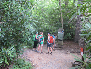
• Caldwell Fork Trail is a moderate trail which follows a rushing mountain river. There are several foot bridges which keep you from getting your feet wet. The trail is heavily used by horse traffic, consequently it is mired in places. The trail travels through a beautiful old poplar forest which is particularly attractive during the fall when the leaves turn yellow. One of the largest trees along the route is 8 feet in diameter. This trail is recommended for winter hiking.
From Waterville, NC, Take the twisty SR 32 south. Bear left at the fork and continue to the Cataloochee Ranger Station. The trail begins between campground and ranger station.
• Cane Creek trail is one of the easiest Cades Cove trails to get to but involves hiking part way up the Cooper Road Trail to get there. The Cane Creek hike is only two miles long and goes through the Cane Creek bottoms (lowlands). The trail goes through land that was once farmed by the Buchanan family but has reforested over time. Features of this hike include eastern Hemlocks and hardwood trees, the Buchanan family cemetery, and a very pleasant, lightly used campsite at Cane Creek. Note: Many low lying trails are often muddy.
• Cooper Road trail offers the Smoky Mountain hiker and horseback rider solitude and an easy path. The trail goes to the park boundary about ten miles away from the trailhead.
If you hike or ride the Cooper Road trail in Cades Cove, you will follow in the footsteps European descent pioneers and Native Americans alike as the Cooper Road trail follows a Smoky Mountain Indian trail that was later improved into a road in the 1830's. Daniel Foute made a white man who obtained great sections in Cades Cove and then sold it to the settlers the improvements a white man who obtained great sections in Cades Cove and then sold it to the settlers. In the 1840's, the road was renamed for Joe Cooper who improved the road for wagon travel in the cove. Cooper road was the best way to for pioneers who lived in the west part of the cove to get through the Smokies to Maryville.
Early Smokies pioneers in Cades Cove grew, made, or hunted just about anything they might want or need and so a trip to Maryville did not need to be made too often. The cove residents went to town for reasons such as, to go to Crawford and Caldwell hardware store or to go to a doctor or to visit a family member. Some others collected chestnuts in one of the many chestnut groves that were prevalent in Cades Cove in those days. After bushels of chestnuts were gathered, a trip from the cove to Maryville would insure a good market for the chestnut crop.
• Chimney Tops Trail (4 miles round trip) This is a somewhat strenuous trail that winds through virgin forest to the Chimney tops pinnacles. It starts at the Chimney tops trailhead, located on Newfound Gap Road. Elevation gain is 1,335 feet. The Chimneys picnic area is located 2.5 miles from the trailhead. Photos
• Crib Gap trail is a horse track that may also be used by people who want a short hike in Cades Cove. Crib Gap was once the main entrance into Cades Cove from Big Spring Cove on the other side of the mountain. Now only GSMNP trails come through the area, one of which is Crib Gap trail.
Crib Gap trail begins on the left side of the Cades Cove Picnic ground and ends as it crosses the Turkeypen Ridge Trail, approximately one and a half miles away. The beginning of Crib Gap trail follows Anthony Creek. As are all the lowlands in Cades Cove, the part of the trail by Anthony Creek is a bit muddy. Hemlocks, so common in the Smoky Mountains grow thickly along the creek but as the trail rises, the hiker climbs to a much dryer pine and oak forest.
• Grapeyard Ridge trail has many creek crossings on log bridges. As you head up Injun Creek you will find an old Indian burial ground then a side trail to visit the McCarter Cemetery, passing many rock piles and stone fences. Next camp #32 where Injun Creek and Grapeyard Ridge trail cross. Go up Grapeyard trail, toward Roaring Fork, looking for a tree with very twisted branches. That tree signaled the spot to start the manway portion of the hike. This manway, in the old days, was used to get from Grapeyard Ridge to Greenbrier. Women rode sidesaddle on this trail to town. The trail is now an overgrown manway, but the trail is still very visible with just a few blow downs. Follow the manway for about 3 miles before coming to a huge hollowed out chestnut stump. At that point take a right turn and go down a fairly steep hill. In about 3/4 mile you will be at the 2nd parking lot you passed to the trail head.
• Gregory Bald is a high meadow that was used in the summer for cattle grazing by the Cades Cove farmers. There are several trails that go to Gregory Bald. This particular trail affords a steady four and a half mile climb to the bald through pine and hardwood forest.
On the way to Gregory's Bald, Smokies hikers will go through Sam's Gap, Panther Gap, and Sheep Pen Gap Backcountry Campsite. From Gregory's bald there are magnificent views of Cades Cove as well as other surrounding landmarks. The Gregory Bald trail continues past the mountain meadow until it ends at the Appalachian Trail. Ambitious Smokies visitors can hike on to the Appalachian Trail; however, keep in mind it is seven and a half miles from the trailhead. A hard days hike is eight to ten miles, so going all the way to the Appalachian trail and back is definitely not a day hike.
To get to the Gregory Bald trail, go down the Cades Cove Loop to the Visitor Center at Cable Mill and follow the signs to Parsons Branch Road. Sam's Gap where the Gregory Bald Hiking Trail begins is five miles down Parsons Branch Road.
• Gregory Ridge Hiking trail - At the Cades Cove Visitor Center take Forge Creek Road until you come to the end. Here you will find one of several trails up to Gregory's Bald. The hike features Gregory's Bald, virgin forest with huge tulip trees, flame azaleas and the highly used campsite number thirteen. Gregory's Bald is one of the high mountain meadows where Cades Cove farmers took their cattle to escape summer heat and flies. Gregory Ridge trail will take seven or eight hours to complete, so be prepared for an arduous hike should you choose it. It may be the most arduous hike in Cades Cove.
Gregory Ridge Trail is a good choice if you want your hike’s destination to have a good view of Cades Cove. So many Smokies visitors hike up the Gregory's Ridge trail for that reason, that it is one of the most popular trails in the Great Smoky Mountain National Park. The trail winds through some of the best of GSMNP, delightful old growth forest and azalea covered Gregory's Bald. In azalea season the experience of Gregory's bald is unmatched, for it is ablaze with breathtaking masses of orange and wine colored blooms, but in the days of old, Cades Cove farmers used to graze their cattle on Gregory's bald, cattle being one of their best cash crops.
To get to the Gregory Ridge trailhead, turn right out of the Cable Mill area parking lot and proceed to Parson Branch road. The parking area marked Gregory Ridge Trail is about five miles down at Sam's Gap. Gregory Ridge trail is one of Cades Cove's most strenuous climbs being four and a half miles up the mountain, but it is well worth the effort.
• The Hannah Mountain trail runs high along a ridge over Cades Cove beginning at Sam's gap and continuing nine and a half miles to Abrams Creek. As eight to ten miles is a very long hike for most people, you probably won't hike the entire Hannah Mountain trail unless you are a serious backpacker used to camping in the back country of the Great Smoky Mountain National Park. This trail is known for its beautiful views of Cades Cove from the grazing land on the crest of Hannah Mountain. One of the notable features of the Cades Cove trail is an enormous tulip tree two miles from the trailhead. It stands majestically on the right, measuring ten feet in circumference. The Hannah Mountain trail has an enjoyable atmosphere, good even footing and historical significance.
Long before the Great Smoky Mountain National Park was formed, Cherokee Indians working for Daniel Foute dug Hannah Mountain trail in the 1840s. He was the owner of the Montvale Resort on Chilhowee Mountain. Foute's purpose in building the trail was to connect his resort to beautiful Gregory's Bald. His trail to Gregory's Bald was a powerful draw for his resort, especially when the azaleas were blooming in the meadows above Cades Cove. The popularity of the Hannah Mountain trail was in part responsible for the resort's long life, bringing Smokies tourists to the mountain meadows of Cades Cove for better than one hundred years.
To get to Hannah Mountain trail you must take the Cades Cove Loop past Cable Mill area. Follow the signs to Forge Creek Road that runs into Parson Branch Road. Travel approximately four miles to the trailhead.
• The Hatcher Mountain trail is a connector trail high above Cades Cove. To get to the Hatcher Mountain trail, you must travel one of the trails it connects to reach its footpath. Trails associated with the Hatcher Mountain trail are located in the west-end of Cades Cove and include Abrams Falls, Little Bottoms, Beard Cane, and Cooper Road trails.
The Hatcher Mountain trail is an easy climb, gaining only seven hundred twenty feet in elevation and taking only an hour and a half to complete. One way to get to the Hatcher Mountain trail is to walk four miles from the Cades Cove floor up the Abrams Falls trail to the Abrams Falls campground.
The Hatcher Mountain trail provides a delightful departure from the more congested Cades Cove hike, the Abrams Falls trail. Though the Hatcher Mountain trail doesn't end in a splendid waterfall, it has its own beauty and character. For this reason, many Smokies visitors wishing to hike in Cades Cove choose the Hatcher Mountain trail spur as a good alternative to continuing on the more popular and crowded Abrams Falls trail. The Hatcher Mountain trail ends when it intersects with the Cooper Road and Beard Cane trails.
Another interesting way to hike Cades Cove via the Hatcher Mountain trail is to use it as part of a loop trail that also includes the Cooper Road trail and the Little Bottoms trail. Contact officials at the Great Smoky Mountain Visitors Center at the Cades Cove campground for details.
To get to the Hatcher Mountain trail, take the Cades Cove Loop five miles just past Abrams creek to a field with a road running through it. There are a number of hikes originating from that location, so you can probably spot the right place just by seeing other cars come in and out. Drive to the rear of the field and park. Follow the signs to the Abrams Falls trail. Go 4.2 miles on the Abrams Falls trail to the Hatcher Mountain trailhead.
• Hen Wallow Falls Trail (4 miles round trip) is a moderate trail that makes a good, short day hike. The main trail leads to the top pof the falls; a steep, narrow side trail leads to the bottom. The trailhead is before the picnic area on the road to Cosby Campground. Elevation gain is 520 feet.
• Indian Creek Falls Trail (2 miles round trip) is a flat trail that offers an easy walk to picturesque Indian Creek Falls which cascades 60 feet down a series of ledges into a wide pool. The trailhead is at the end of Deep Creek Road just past the Deep Creek Campground. Elevation gain is 100 feet.
• Indian Grave Gap hiking trail connects Rich Mountain Road with Scott Mountain trail. To hike the Indian Grave Gap trail, travel the Cades Cove Loop to Rich Mountain Road. Turn right and take Rich Mountain Road to the Indian Grave Gap trailhead. Hike across the face of Rich Mountain as far as you care to go. It is about three and a half miles to the end of the trail when it runs into the Scott Mountain hiking trail.
The last part of this Cades Cove hiking trail is significant as part of the Rich Mountain Loop trail.
• Laurel Falls Trail (2.5 miles round trip) is the most popular waterfall trail in the park. The paved road is relatively flat and passes through a forest of pine and oak trees. The trailhead is located at the Laurel Falls parking area on Little River Road just a few miles past Sugarlands Visitor Center. Elevation gain is 200 feet.
• The Little Bottoms trail to Cades Cove is quite long and is not well defined. It is most suited to hikers who are experienced in hiking in the backcountry and are personally familiar with Cades Cove's trail system.
This trail is a little different than most of the hikes in this section as the destination not the origination is Cades Cove. Take US 321 from Maryville until you come to Foothills Parkway. Turn right and go to U.S. 129 and turn left. Drive a hundred yards or so and turn left on Happy Valley Road. Travel to the Happy Valley Loop Road and turn right. About a mile down the road you will find parking for the Cooper Road Trail. You must travel a short distance down the Cooper Road trail to reach the Little Bottoms hiking trail. The Cooper Road trail begins at the far end of the campground. Follow the Cooper Road Trail to the Cooper Road Backcountry campground. On the right of the Cooper Road campsite, you will find the beginning of the Little Bottoms hiking trail. Follow the Little Bottoms trail to the Abrams Falls trail and hike it down into Cades Cove. This trail is not well defined so know it is not for novices, and even experienced hikers should take proper precautions. Turn around and retrace your steps if you lose the trail.
• Old Sugarlands Trail was the original first paved road to Newfound Gap. Before the road was paved it was a wagon road through the center of the Sugarlands Community. A quarry near the trail was used to build the first paved roads over the mountains. The first 1.5 miles are narrow and flat. If you look carefully, the signs of the past inhabitance can been seen from the work of the CCC. At 2 miles the trail begins a gradual climb. After the nice climb you have reached the second portion of the trail. Turn left heading down the Cherokee Orchard Road, and you will see the trail head to the next trail "Twin Creeks trail" This trail follows the road for only a short distance then heads off into the thick trees. You will have a minor creek crossing. This trail takes you to the Ogle home. Follow the road into Gatlinburg, have some lunch, then head west on 441 and you will see the last leg, Gatlinburg Trail. This 2.5 miles follows the river, is peaceful and flat.
To hike: from Sugarlands Visitor Center, walk through the breezeway past the front of the Ranger Station (a large white building), across the bridge then across the road (Hwy 441, Newfound Gap Road). Trail begins by seeing a bench mark and sign.
• Rabbit Creek trail. Although Cades Cove's Rabbit Creek trail goes to Mill Creek, Andy McCully Ridge, Rabbit Creek Backcountry campground, Scott Gap, Pine Mountain, Abrams Creek and a ranger station, some feel this hike has no particular features. Perhaps that is true when compared with some trails that feature high mountain meadows with their splendid views of Cades Cove, but what this hike lacks in exciting destination, it makes up in solitude. The Rabbit Creek hike features virgin stands of hemlocks, oak and pine with varied terrain running along ridges and hollows.
Rabbit Creek follows the path of a road that once was used to get in and out of Cades Cove. The Great Smoky Mountain National Park service maintains this road as a hiking trail. To get to Rabbit Creek trail, follow the Cades Cove Loop Road to the back of the cove, about five miles. You will cross Abrams Creek and then take a right through a field. Drive to the rear of the field and park. There will be a path and signs pointing out several hikes, one of which is the Rabbit Creek Hiking Trail.
• Rainbow Falls Trail is a fairly challenging trail if completed all the way to Mt LeConte. It takes about an hour and a half to hike to Rainbow Falls and four hours to Mt LeConte. Hikers will gain nearly 4,000 feet in elevation by the time they get to Mt. LeConte.
Directions: Turn at light #8 in Gatlinburg and follow Historic Nature Trail 1 mile into Great Smoky Mountains National Park. The name will change from Historic Nature Trail to Cherokee Orchard Road. About 2.5 miles after entering the Park, Cherokee Orchard Road approaches the Rainbow Falls parking area. You will find the trail head at one edge of the parking area.
• Ramsay Cascades Trail (8 miles round trip) is a strenuous hike leading to the park's highest waterfall. It passes through an old growth deciduous forest before reaching the 100-foot high Ramsay Cascades. Do not attempt to climb to the top of the falls; several attempts have resulted in fatalities. From Greenbrier, follow signs to the Ramsay Cascades trailhead. Elevation gain is 2,375 feet.
Trail
• Rich Mountain Loop trail offers a peaceful hike with May blooming mountain laurel and excellent fall color, not to mention many views of the Cades Cove and the surrounding Great Smoky Mountains. The trail is flat in the beginning as it follows an old roadbed which tracks near the Oliver cabin.
You will notice many fields cleared on this end of Cades Cove. The fields that were cleared by the pioneers would have been reclaimed by forest were it not for efforts of The Great Smoky Mountain National Park service which keeps some fields in Cades Cove clear to show Smokies visitors how the cove looked during the 1800's.
The Rich Mountain Loop trail is a moderately difficult hike, following three of the many Indian trails in Cades Cove to make a loop. The Rich Mountain Loop trailhead is a short distance down Cades Cove Loop Road from the parking and information area.
To follow the Rich Mountain Loop, begin at the trailhead of the Rich Mountain Loop trail. After walking one half mile you will need too veer left at the junction with the Crooked Arm Ridge trail to stay on Rich Mountain Loop trail. After a good bit of walking--two and a half miles, you will next go right when the Rich Mountain Loop trail intersects the Indian Grave Gap trail. Hike about one mile on the Indian Grave Gap trail and then go right on the Crooked Arm Ridge trail. In about two miles the Crooked Arm trail will intersect with the Rich Mountain trail one half mile from the beginning of the hike. The Rich Mountain Loop trail is 8.5 miles long and accommodates both horses and hikers.
• Rich Mountain Trail - on the Cades Cove Loop and up the Rich Mountain Road are three trails, one of them the Rich Mountain Trail. The Rich Mountain trail has a couple of alternatives. The first alternative begins at the trailhead on Rich Mountain Road on the north side of Cades Cove and descends to the Indian Grave Gap trail. That is actually the end of the Rich Mountain trail, a distance of slightly over two miles. Once you reach Indian Gap trail, the first alternative is to turn around and hike the two plus miles back up the mountain to your car. The Rich Mountain trail offers peace and quiet, beautiful forests and the lovely cascades on Hesse Creek.
Rich Mountain Trail Alternatives:
If you are hiking with a friend and come in two cars, you have a couple of alternatives when hiking the Rich Mountain trail. To utilize them one person needs to leave their car at the parking area for the Rich Mountain Loop trail that is near the beginning of the Cades Cove Loop. Next, both of you drive up Rich Mountain to the Rich Mountain trailhead. Hike the Rich Mountain trail down to the Indian Gap trail. At this point you can turn either left or right on Indian Gap.
Left on Indian Gap trail:
If you turn left on the Indian Gap trail, take a right at the Crooked Arm Ridge trail. Hike Crooked Arm Ridge trail down to the Rich Mountain Loop trail, bearing left. That will take you back to the Cades Cove Loop Road close to the Rich Mountain Loop trail.
Right on Indian Gap trail:
If you turn right on the Indian Gap, turn left onto the Rich Mountain Loop trail and hike it all the way down to the Cades Cove Loop Road. You will see the trailhead and your friend’s car.
• Rough Fork Trail is a 6.5 mile trail that follows a beautiful trout stream along a gravel road in the mid section of the Cataloochee Valley. The trail passes several old farm sites which offer views of old hardwood forests. The trail narrows midway following an old railroad grade for a couple miles until it reaches Polls Gap Trail. There is a primitive campsite along the route.
From Waterville, NC, Take the twisty SR 32 south bearing left at the fork and travel to the Cataloochee Ranger Station. Trail begins southwest of the ranger station.
• Russell Field Trail. As its name implies, Russell Field trail ends on one of the mountaintop balds, Russell Field. The balds were important in early Cades Cove life as they were used by early frontiersmen and farmers for the grazing of cattle. Other fields used for this purpose are Gregory's Bald and Spence Field. All three are high on the mountaintops overlooking Cades Cove and have one or more hiking trails leading to them.
The Russell Field Trailhead is in the Cades Cove picnic area, just before the Cades Cove Loop Road. The trail winds through old growth hemlocks and follows the left prong of Anthony Creek. Along the way this Smoky Mountain trail goes by ideal campsites for those planning to camp in GSMNP. Once you reach the summit of Russell Field the view is wonderful, but some Smokies visitors are disappointed that trees obscure some of the view of the Cades Cove floor. These trees were not present in the 1800s. Fewer trees allowed for more grass for the cattle and more views of the surrounding area for those tending the cattle. Though the Great Smoky Mountain National Park officials are allowing some of the trees to grow back, they are still committed to maintaining most of the bald as a historical field.
Scott Mountain trail. About two miles above the Cades Cove Loop, at the intersection of Indian Gap and Crooked Arm Ridge trails, the Scott Mountain trail begins, ascends and eventually descends approximately three and a half miles to the Schoolhouse Gap trail. This trails greatest feature is that of solitude as it takes you on a hike away from Cades Cove. The Scott Mountain trails greatest drawback is that you must hike miles before reaching its beginning.
To reach the Scott Mountain trail, take the Cades Cove Loop Road to the trailhead of the Rich Mountain Loop trail, which is near the orientation shelter at the beginning of the cove. Walk one half mile up the Rich Mountain Loop trail and bear right on the Crooked Arm Ridge trail. Two and a half to three miles up the Crooked Arm Ridge trail there will be an intersection with the Scott Mountain trail. Turn right onto it. Keep in mind when choosing a hike in Cades Cove that a difficult day of hiking is six to eight miles for most people in good shape and that this hike together with the effort to reach it is about seven miles one way.
• Sugarlands Valley Nature Trail (3,000 foot loop) is a paved trail built in 1993 to accommodate visitors with disabilities. The level trail leads to distinct forest life zones, a river and the remains of pre-park dwellings. Special communications media assist in interpreting nature and is available at the Sugarlands Visitor Center. The trail is a favorite with visitors with mobility and sensory impairments as well as with older visitors and families with children in strollers. The trailhead is located off Newfound Gap Road, one fourth mile south of Sugarlands Visitor Center.
• Trillium Gap trail is the only horse trail to Mt LeConte and is traveled three times a week by llamas transporting supplies to the LeConte Lodge, except during the winter season, when the lodge is temporarily closed.
The Trillium Gap Trail begins its 6.5 mile journey up the northern face of Mt LeConte at an elevation close to 3,200 ft. Although an easy trail, this portion of the trail does have many small creek crossings, so the hiker may want to brush up on rock hopping skills before hiking this trail. After the third small stream, Grotto Falls is 1.3 miles. Here Roaring Fork tumbles thirty feet over the falls. Grotto Falls is one of the most picturesque waterfalls in the park. The trailhead is located inside Great Smoky Mountains National Park, about 7.5 miles from Gatlinburg, Tennessee, off Roaring Fork Motor Nature Trail.
• Twin Creeks Trail is more rugged than most trails in the Smokies. The forest here is scraggly and seems to be struggling to recover from years of pre-park farming and clearing. Poison ivy covers the trail, and you’re within earshot (sometimes eyesight) of the road the entire way. This is an easy family walk.
• Wet Bottom Trail. Used as a horse trail, the Wet Bottom Trail is one of Cades Cove's shortest hikes with only one hundred forty feet altitude gain. To get to this hike, take the Cades Cove Loop Road five miles. After crossing Abrams Creek, turn right on a gravel road that runs through a grassy field. Park at the back of the field where there are signs posted. Walk into the forest one tenth of a mile. There you will find a wooden bridge that crosses Abrams Creek. Continue to follow the signs for the Wet Bottom Creek trail.
The Wet Bottom trail follows Abrams Creek and can be, as its name implies, a bit marshy. All of the low-lying areas in the far end of Cades Cove are prone to be water logged. The early settlers avoided building their farms in the marshy end but did use its cane breaks to protect their cattle in the wintertime. Eventually, people also settled even the marshy end of Cades Cove. The Great Smoky Mountain National Park service preserved one of their homesteads, the Elijah Oliver Place. If you want, follow the signs near the beginning of the Wet Bottom trail to take a side trip to see Elijah Oliver's homestead before continuing on the Wet Bottom trail as far as you like. When you think you've gone far enough turn around and retrace your steps back to the parking area and the Cades Cove Loop.
More Hiking Trail Information
HikingintheSmokys.com - Search for more than 70 trails by trail key features, by rating difficulty, by location within the Park or by using the alphabetical listing.
Smoky Scout's Hiking Adventures
Life in My Little Corner
The best day hiking ever in the Great Smoky Mountains National Park
| Trip Ideas Great Smoky Mountains Facts Institute at Tremont Transportation & Airports Local News Photo Tours • Fall Photo Tour • Roaring Fork Motor Nature Trail • Smoky Mountain Fall Foliage • Fall Foliage at Kuhowi • Fall Colors in nearby towns • Fall in Wears Valley • Best Fall Hikes |
WHAT TO DO Attractions Biking Fishing Hiking Outdoor Adventure Scenic Drives Shopping Heritage, History, & Culture Nature Activities 4 SEASONS Winter Spring Summer Fall WEDDINGS Wedding Services Honeymoon Cabins |
WHERE TO EAT Restaurants Farmers' Markets Recipe Cards Surrounding Towns: • Cherokee • Gatlinburg • Pigeon Forge • Townsend • Wears Valley CONTACT |
||