Great Smoky Mountains National Park
 Cades Cove
One of the most popular day trips in the Smoky Mountains is to Cades Cove. Plan to spend at least 2 to 3 hours in the Cove where you will want to make frequent stops to view historic buildings, wildlife, scenic views, and maybe take a hike. There is a picnic area with BBQ grills. There are also several areas throughout the Cove where you can enjoy a picnic, but there are no tables. Close to Cades Cove is Townsend, TN which has several really great mom and pop restaurants.
Map & Directions
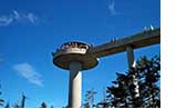 Kuhowie
Kuhowie is the highest point in the national park. It is the highest point in Tennessee, and the second highest point east of the Mississippi River. The Dome is situated half in North Carolina and half in Tennessee. The peak is accessible after driving Clingmans Dome Road from Newfound Gap, and then walking a steep half-mile trail. A paved trail leads to a 54-foot observation tower. The Appalachian Trail crosses Kuhowie, the highest point along its 2,144 mile journey.
Map & Directions
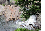 The Sinks
This section of the park is magnificent with its rushing waters and gigantic boulders. Many people swim in its rivers, but the National Park Service does not recommend this because waters can rise rapidly and undercurrents can be very strong. It is beautiful to view and is a great spot for photography. There is a hiking trail, and wildlife can often be seen here. The Sinks area is situated between Townsend, TN and Gatlinburg, TN. The drive is wonderful with lots of scenic views.
Map & Directions
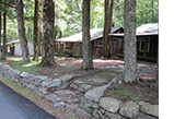 Elkmont
Elkmont was originally a resort area for wealthy people from Maryville and Knoxville TN during logging days. The town was abandoned when Great Smoky Mountains National Park was established. It is now an historic district which includues the original cabins and a clubhouse which was refurbished in 2012. The area is situated on the Little River Gorge River and contains a campground. Elkmont is 5 miles from Sugarlands Visitor Center.
Map & Directions
 Cherokee Indian Reservation
The reservation is located on the North Carolina side of the national park. There are many shops, an art gallery, restaurants, and Harrah's Cherokee Casino which also has a number of restaurants accessible to any age group. Events schedule. Annual festivals, a carnival in the fall, a Cherokee Pow Wow, an outdoor Indian drama about the infamous Trail of Tears, an excellent museum about the Cherokee, fishing tournaments, and rod runs. Every Friday and Saturday night during the summer there is a Cherokee Bonfire where you can hear stories and legends that have been passed down generation to generation from some of the greatest storytellers in Cherokee. Map & Directions
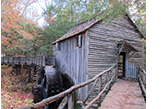
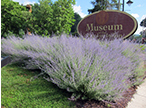
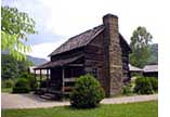 Oconaluftee Farm Museum
The Mountain Farm Museum sits on the banks of the Oconaluftee River just inside Great Smoky Mountains National Park. Here you will find a collection of of southern Appalachian farm buildings assembled from different locations throughout the Park.
The farmstead has a crop in the field with the Smoky Mountains as a back drop. Live farm animals are raised during the summer. You can visit the chestnut log farmhouse, barn, hen house, apple house, springhouse, and blacksmith shop. During the summer months, Great Smoky Mountains National Park staff and volunteers give demonstrations of traditional Smoky Mountain ways at the Mountain Farm Museum, including black-smithing, plowing, and molasses making.
Map & Directions
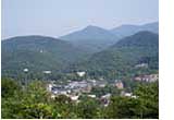 Gatlinburg Scenic Overlook
This section of the national park is located on the Gatlinburg Bypass which is accessible from The Spur (the section of the park that runs from Pigeon Forge to Gatlinburg). There are four overlooks on the Bypass which provide outstanding views of downtown Gatlinburg and its mountain backdrop. You will be able to see the entire downtown area of Gatlinburg, including the Parkway, the Gatlinburg Space Needle, and the Park Vista Hotel which sits atop a mountain above Gatlinburg. The views are spectacular at any time of the day. In the mornings, you will probably see mist (also known as Blue Smoke) rising from the valley. Evening views are magnificent as you view all the lights of the city, including those from the Space Needle.
Map & Directions
| Trip Ideas Great Smoky Mountains Facts Institute at Tremont Transportation & Airports Local News Photo Tours • Fall Photo Tour • Roaring Fork Motor Nature Trail • Smoky Mountain Fall Foliage • Fall Foliage at Kuhowi • Fall Colors in nearby towns • Fall in Wears Valley • Best Fall Hikes |
WHAT TO DO Attractions Biking Fishing Hiking Outdoor Adventure Scenic Drives Shopping Heritage, History, & Culture Nature Activities 4 SEASONS Winter Spring Summer Fall WEDDINGS Wedding Services Honeymoon Cabins |
WHERE TO EAT Restaurants Farmers' Markets Recipe Cards Surrounding Towns: • Cherokee • Gatlinburg • Pigeon Forge • Townsend • Wears Valley CONTACT |
||